


Expedition to the American Badlands, Part I
I saw the nearly life-size cardboard cutouts everywhere- restaurants, saloons, souvenir shops, even gas stations. Wherever I wandered through “John Wayne country,” a place of sprawling red deserts, towering buttes and mesas and bone-dry ancient seabeds. It’s harsh and inhospitable to most creatures that don’t have scales or stingers, but there he was, ready to draw. Saddle up, pilgrim, it’s going to be a hot, dusty, spectacular ride.
The 2024 Harley-Davidson Hydra-Glide Revival is right out of America’s “Golden Age of Design,” the Space Age thrust into artful forms of innovation and style. The Revival is an homage to the original 1956 Hydra-Glide (1949-’57), which introduced hydraulic front forks. It’s the fourth iteration in the Motor Company’s limited edition and numbered Icons collection, its factory version of a resto-mod. Earlier Icons included the 2023 Electra Glide Highway King, 2022 Low Rider Diablo and 2021 Electra Glide Revival. Vintage looks with modern works can be an irresistible combination.
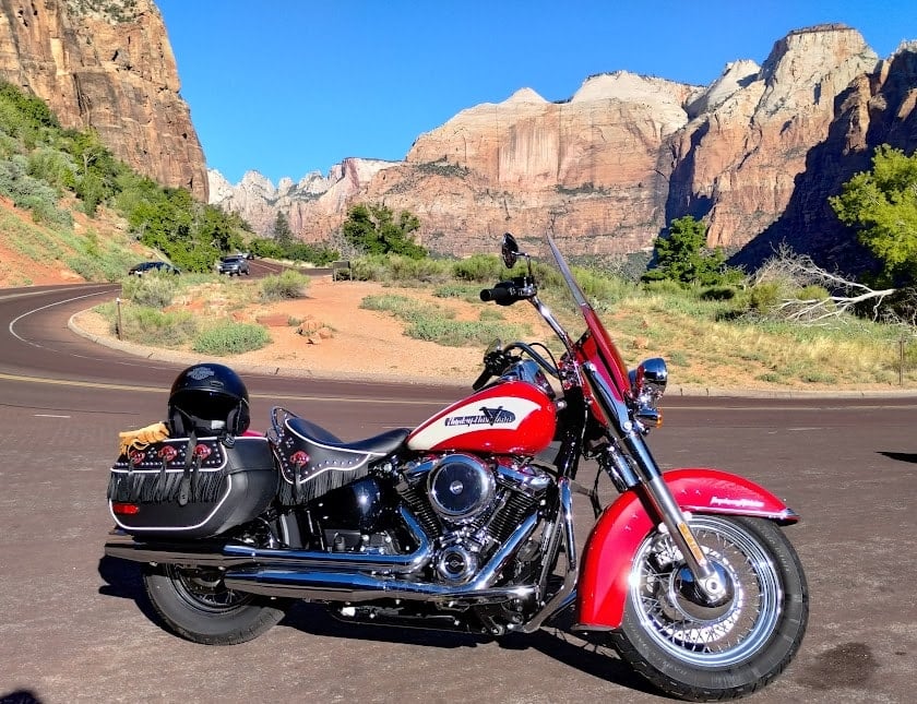
The 2024 Harley-Davidson Hydra Glide Revival, in its natural habitat.
The new Hydra-Glide was a fitting ride. Its inspiration came from the same classic era of Hollywood westerns. The 1950s saw Wayne and his contemporaries shape the image of the American cowboy, with an assist from John Ford and the otherworldly landscapes of southern Utah and northern Arizona, as well as ruggedly bizarre bits of New Mexico and Colorado. Large swaths of the Colorado Plateau are where these states have tucked away many of their scenic treasures. This is a biker’s paradise. Sometimes it looks too unimaginably beautiful to be real. Sometimes, it looks more like movie set.
The iconic western cowboy, with his freedom-loving, horse-riding, leather vest, big black boots and chaps wearing derring-do resembled, well, us. Or at least the us in our heads. Just because our horses happen to have motors shouldn’t diminish the obvious DNA trail from horsey cowboy to iron cowpoke. Or maybe I just watched too much Bonanza as a kid. My gear outfitter says he’s counting on it.

The vastness and grandeur of this land is almost overwhelming.
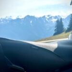
Whatever got us going, we took aim at the red rock wonderlands of John Wayne Country. Ancient shallow seas invaded and retreated countless times over millions of years, depositing sediments layer by layer until time and pressure turned them into rock, which erosion slowly carved into the astonishing shapes we see today. Destinations on our odyssey through geologic time included Zion, Bryce, The Grand Staircase, Capitol Reef, Marble Canyon, patches of the Navajo Reservation, Monument Valley, Moab and quickening points unknown. Riding among the towering rocks, diving into the craggy canyons, ascending mesas and rolling over the remains of ancient seas, taking a turn and suddenly beholding something that changes your sense of reality, this is planet Earth at its most supernatural.
The posse included the Brothers Gibbs, baby brother Tom (61), eldest brother Bob (68 and three days) and myself (68). Both brothers have made me feel like their flesh and blood for the past 50 years, give or take, so this was a family ride. We rendezvoused in Las Vegas, Tom from somewhere in the Pennsylvania woods, Bob from San Diego and me from Los Angeles. It was 97 degrees in the stalled traffic. The heat coming off the 114 cubic-inch (1868 cc) air-cooled motor was cooking my thighs. I didn’t care, we were all together again, even if I felt like tenderloin on a spit.

The brotherhood of the road.
The last epic brothers’ ride was 17 years ago, which still feels like yesterday. That odyssey extended to Colorado and New Mexico, places dark and parts unknown, random bits of the other Four Corners. We plan to roll out again in another 17 years, just like cicadas. If you see us on the road, please don’t run over and squish. Up close we’re kinda’ cute and mostly friendly.
Out of Vegas, we were finally free. It felt good to be out on the open road, even if our first miles were on I-15. Once in Utah, we found Route 9 east, passing through Springdale, once a sleepy little desert town now bustling with tourists and trendy cafes, restaurants and shops. I suppose this appeals to some, especially if you think spending eight bucks on a cup of coffee is normal, but culturally it feels sterile. Route 9 delivered us right into Zion National Park. I like that the Harley’s retro red matched the red rocks towering over us. Felt like kin.

The road before us.
You may not always feel like stopping, but a visit to the Visitor Center can save time and help you make better road decisions. This time it didn’t. We meandered a bit, looking at t-shirts and wildlife books we didn’t buy and, of course, trying to find the damn bathroom. Old biker wisdom suggests never miss a chance to get gas or use the bathroom. I may have actually read that on a t-shirt, printed in saltier language, but the message is still worth repeating. Rest stops are always a welcome sight, even if they’re disguised as visitor centers.
Route 9 slices through the park, past the closed-to-motor-vehicles Scenic Drive, which follows the unexpectedly toxic Virgin River. Do not dip a toe in the inviting waters. Algae blooms have produced cyanobacteria and it does not like us, not even a little bit. We were to later discover most rivers we crossed ran bad water, not matter how pristine they looked. They were contaminated with killer bacteria of one sort or another. However, this did not seem to bother one wild turkey. I think it gave me a wiseass smile when it was done drinking. Regardless, neither drink from nor skinny dip in these tempting waters. One would think a cool river running through a burning desert would offer the perfect, splashy reward. But, no. No matter where you are, surface water can make you sick, or worse. Check locally before jumping in.

The great abyss running up to the Vermillion Cliffs.
The Scenic Drive is accessible by shuttle bus, by bicycle, and apparently electric bikes, which seems the happiest way to go, according to one couple who looked like they were grown in a fitness lab. The shuttles run regularly, but can get sardine-can crowded.
We rolled through this off-world like towering spectacle of sandstone, trying to burn as much as possible into our eyeballs while not riding off a cliff. Past whimsically named peaks such as the Mountain of Mystery, the Great White Throne, Mount Majestic, Angel’s Landing, Lava Point, the West Temple and Zion’s highest peak, Horse Ranch Mountain, standing at a sheer 8,726 feet, we were at the gates to the red rock wonderlands. Zion is simply spectacular, but so much more was to come.

These lands fill the senses.
We carried on through the Zion-Mount Carmel mile long tunnel, popping out on the red paved road toward Mt. Carmel Junction, staying on Route 9 east to Route 89 south and our cowboy camp in Kanab. And by camp I mean hotel. John Wayne was waiting for us. He always had the same pose, though, kind of stiff and parochial and ready to plug you. We returned to Zion the next day for another look, eventually exiting at Springdale, where we first entered the day before. I was told by a park ranger the ride back to Kanab in that direction was “nothing special.” It was a wild understatement. Route 9 west through Virgin, then east on Route 59 at Verkin, continuing past Hurricane and Apple Valley as it turns into 389, and finally north at Fredonia on 89 back to Kanab gave us reason to relocate there.
Kanab was well known as base camp for many Old Hollywood westerns. Some 100 movies were shot, at least in part, in or around the desert town, including Wayne’s The Big Trail (1930), which was filmed in Zion and just south of town. Also known as Little Hollywood, Kanab hosted The Lone Ranger, Billy the Kid, El Dorado and the TV series, Gunsmoke. This was the Wild West alright, and it wasn’t made of celluloid.

Colorado River from the Navajo Bridge.
We stayed a night at the Parry Lodge, which served as the de facto studio headquarters during Kanab’s heyday. Kanab still sees some filming, offering a visceral connection to the wild open range like no other. This is a place too beautiful not to photograph. Nearby, at the Little Hollywood Museum, you can walk among the building fronts of some of your favorite western movie sets.
The next morning we headed to Bryce, about 100 miles from Kanab and up in average elevation to 8,300 feet, about 3,300 feet higher than the cozy Parry Lodge. That elevation change can translate to a 10- to 20-degree difference. The climb can feel pretty chilly, so dress in layers and always keep a bit more in your saddlebag. A wool scarf, warm gloves, and a ski mask thin enough to fit under your helmet are recommended. The Hydra-Glide proved to be a versatile ride,
unbothered by elevation or temperature, delivering performance and comfort that made me hope Harley forgot they leant it to me. They didn’t.

The hoodoos of Bryce.
Bryce is famous for its hoodoos, eroded rock columns standing like sentinels over a landscape that barely looks real. The Paiute tribe were the last indigenous people to occupy the canyon. According to their lore, the hoodoos were people who were turned to stone for committing bad deeds. Uh oh. Not quite like Lot’s wife, but close enough.
You can say hello to these stoney no-gooders in person if you choose to hike down, then back up, one of the trails. We did not. Leather motorcycle jackets, jeans and big black boots are not trail friendly, especially relatively steep ones. At other locations, we did see some motorcyclists change at least their boots, leaving them next to their bikes, as if only their invisible “domain” would protect them. Apparently, it did.

Our array of steel horses.
There is an 18-mile scenic drive that runs through Bryce, although you need to pull into the lookouts to see the scenery. The four main ones are Bryce Point, Inspiration Point, Sunset Point and Sunrise Point. All are worth a good gander, the latter three preferred, at least by me. I suggest go directly to the furthest overlook and stop on the way back, making right turns rather then left against the busy drive.
Bryce is beautiful, but we felt satisfied after lingering at four overlooks, doing a fair amount of walking and shooting at each. Time to get back to Kanab and rest up. Heading south on Route 89, following the meandering Sevier River to the east, we stopped for food and gas at the town of Hatch, having an early dinner at the Hatch Station Cafe and Motel. Good food that really hit the spot after a long day. Next time, we might stay in the whimsical, Harley-themed Galaxy Motel, just a sandstone’s throw from the cafe.

Rolling ever on.
The next day would carry us roughly 250 miles from Kanab to Mexican Hat. We ran south on Route 89 to Fredonia, turned east on 89A, continued through the Kaibab National Forest, passing Jacob Lake, and came within 25 miles of the Grand Canyon’s North Rim. Then our world exploded. Riding through the remains of Kaibab’s 2020 72,000-acre Mangum Fire, turning just another forested curve, the road dropped and suddenly opened up to the great, soul shocking expanse of the Vermilion Cliffs below. The view of what looks like an ancient seabed rising to soaring red stone cliffs is spellbinding. We stayed awhile, just staring, in disbelief and wonder.
After finally finding our breath again, we continued down 89A, flanks of crimson cliffs, giant boulders and small buttes grew as we rode. We stopped at the roadside attraction called Cliff Dwellers to take it all in, stretch our legs and visit the Native American tables offering handmade jewelry and other items. This is Marble Canyon, which strangely enough, contains no marble, just sandstone wind-polished enough to resemble marble. The Outlaw Josey Wales, among other westerns, was shot there. Sadly, John Wayne was not to be found. The area falls under the domain of the BLM, and according to locals, the old homesteads are long gone and no one calls it home nowadays, although I was welcome to move into the cliff-stone and boulder cabin just yards away. I’m thinking clubhouse.

We could make this work,
Just down the road is the Navajo Bridge, a great place to stop for a long look at the Colorado River. Vantage points from the Grand Canyon, Hoover Dam and other overlooks don’t offer the proximity to the river like Navajo Bridge, far as I’ve seen. Cross the bridge and you’re in the Navajo Nation, the largest indigenous reservation in the country. In the shade of the bridge lay more native offerings. Authentic earrings, bracelets, pendants, necklaces, medicine bags, stone or bone fetishes can be found, as well as the occasional handmade knife and other leather goods. There used to be a fair number of these roadside markets, but they are now few and far between. Riding across most of the length of the Rez, we didn’t see another.
We continued on Route 89 north to Page, AZ for a break. I’ve found gas station attendees make good meal recommendations, and if you have the time, local things to do and see. We didn’t- time was moving faster than we were. Slicing through the Rez down Route 98, flanked on the north by the Rainbow Plateau and Mormon Ridges to the southwest, passing Kaibito and spilling out onto Route 160, we turned northeast, gassing up again in Kayenta, turning north on Highway 163. Straddling the Arizona/Utah border, next stop, the Martian world of Monument Valley Navajo Tribal Park, and birthplace of John Wayne. Or at least the western legend of John Wayne, bore by cantankerous director John Ford.

Well worth the stop.
Wayne would make five movies here- Stagecoach (1939), Fort Apache (1948), She Wore a Yellow Ribbon (1949), Rio Grande (1950), and The Searchers (1956), arguably the typecast actor’s most complex, layered role. We would make none. Not that we didn’t want to. The park is a crossroads of native culture and earth shaping forces. The red sand desert yields to giant sandstone monoliths reaching for the big sky, like an outlaw pointing a six-shooter at your nose and yelling hands up. And maybe I watched too much Gunsmoke as a kid. Regardless, the contrasts are vivid and mesmerizing. Take plenty of pictures from every angle, but also use all your senses to bury the images deep in your mind.
The 17-mile Valley Drive loops around the monuments and is the only motorized access to the park. You can also drive your automobile, if you happen to have one, or take a guided jeep/truck tour, which is probably a good idea if you want to understand the place better. Motorcycles used to be allowed on the sandy road, but no longer. Probably because of me. Some years ago, I took a large and ungainly Moto Guzzi down Valley Drive, frequently fishtailing through the loose sand. Kind of fun, but my companion thought not, and about a half-mile before leaving, disembarked and walked back. Without the screaming, I could linger on the great solitude and boundless raw splendor of the valley. Today, I can again.

Breathtaking.
The word “Navajo” is actually a Tewa pueblo tribe word roughly translated into Spanish. The Navajo call themselves Diné. They have lived in these rocky lands for hundreds of years. Monument Valley (Tsé Biiʼ Ndzisgaii or “valley of the rocks”) is sacred to them, possessing powerful spirituality. It remains home to many tribal traditions, legends and tales.
Staring out at the 192-million-year-old East and West Mittens Buttes, both soaring past 6,100 feet, trying to wrap my mind around the fathomless time and forces still at work here, imagining the countless generations of people who have passed before this very spot, I look over at the Harley, and linger still. The road can wait. For now.
More to come.
J. Joshua Placa

Further up and further in.


Tales told by a true storytelling biker. I can visualize the ride and the view from the lookouts. Beautiful tribute to John Wayne and the western bad lands.
Thank you, Brother Greg, appreciate the kind words.